
 |  |  |  |  |  |  |
|---|
OUR RESEARCH
The research undertaken by the Marine Mapping group focuses primarily on understanding the relationships between abiotic and biotic processes in the marine environment, and their impact on the patterns of distribution and abundance of sessile and mobile marine organisms.
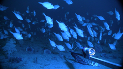
To undertake this research, we have the latest advances in marine exploration tools at our disposal, including; remotely operated vehicles (ROVs), high definition baited stereo cameras (stereo BRUVs), precise spatial positioning systems (RTKGPS), motion sensors, acoustic transponders, multibeam sonar system and a dedicated 9 metre research platform Yolla for open coast scientific research. Technical specifications for Yolla can be viewed here
These tools, together with rapid advances in marine remote sensing data, are enabling us to close this knowledge gap and provide an opportunity to gain an understanding of the mechanisms by which spatial patterns influence key ecological processes.
Research projects include:
· habitat mapping
· quantitative spatial ecology (including fish-habitat associations)
· physical surrogacy
· sonar water column and backscatter analysis
· seascape connectivity
· sea level and shoreline change
· remote sensing (including change detection and classification methods)
· marine national park assessment
· spatial technologies in fisheries
OUR EQUIPMENT


